


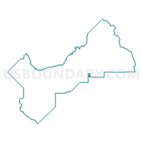
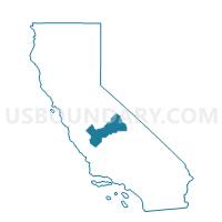
Voting District 54605, Fresno County, California
About
Outline

Summary
| Unique Area Identifier | 530107 |
| Name | Voting District 54605 |
| County | Fresno County |
| State | California |
| Area (square miles) | 8.02 |
| Land Area (square miles) | 8.02 |
| Water Area (square miles) | 0.00 |
| % of Land Area | 100.00 |
| % of Water Area | 0.00 |
| Latitude of the Internal Point | 36.68991400 |
| Longtitude of the Internal Point | -119.28645540 |
Maps

Graphs
Select a template below for downloading or customizing gragh for Voting District 54605, Fresno County, California


Neighbors
Neighoring Voting District (by Name) Neighboring Voting District on the Map
- Voting District 43355, Fresno County, CA
- Voting District 43920, Tulare County, CA
- Voting District 43930, Fresno County, CA
- Voting District 54580, Fresno County, CA
- Voting District 54620, Fresno County, CA
- Voting District 54665, Fresno County, CA
Top 10 Neighboring County Subdivision (by Population) Neighboring County Subdivision on the Map
- Sierra CCD, Fresno County, CA (18,981)
- Orosi-Cutler CCD, Tulare County, CA (18,269)
- Orange Cove CCD, Fresno County, CA (10,821)
Top 10 Neighboring Place (by Population) Neighboring Place on the Map
Top 10 Neighboring Unified School District (by Population) Neighboring Unified School District on the Map
Top 10 Neighboring State Legislative District Lower Chamber (by Population) Neighboring State Legislative District Lower Chamber on the Map
Top 10 Neighboring State Legislative District Upper Chamber (by Population) Neighboring State Legislative District Upper Chamber on the Map
Top 10 Neighboring 111th Congressional District (by Population) Neighboring 111th Congressional District on the Map
Top 10 Neighboring Census Tract (by Population) Neighboring Census Tract on the Map
- Census Tract 64.03, Fresno County, CA (6,304)
- Census Tract 65.02, Fresno County, CA (4,159)
- Census Tract 2.02, Tulare County, CA (2,663)